Reduced transportation and industrial fuel consumption created a superficial surge in coral reef growth and reduced air pollution, among other environmental benefits. According to data from the European Space Agency (ESA), air pollution is once again returning to pre-COVID-19 levels.
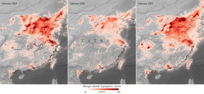
The maps show the monthly average concentrations of nitrogen dioxide (NO2) derived from data from the Copernicus Sentinel-5P satellite, in the central and eastern portions of China in February 2019, February 2020, and February 2021. The map shows the fluctuation in levels between the three periods, with dark red indicating high concentrations of NO2.
The data indicate that NO2 concentrations in Beijing dropped by around 35% between February 2019 and 2020, before returning to similar levels in February 2021. Similarly, in Chongqing, China, NO2 levels dropped by approximately 45% between February 2019 and February 2020 before returning to almost double pre-COVID numbers.
Claus Zehner, ESA’s Copernicus Sentinel-5P mission manager, says, “We expected air pollution to rebound as lockdowns are lifted across the globe. NO2 concentrations in our atmosphere do not depend on human activity alone. Weather conditions such as wind speed and cloud cover also affect those levels, however a large quantity of these reductions are due to restrictions being eased. In the coming weeks and months, we expect increases of NO2 concentrations also over Europe.”
These data are thanks to the Tropomi instrument on board the Copernicus Sentinel-5P satellite —the first Copernicus mission dedicated to monitoring our atmosphere.
“The special features of the Copernicus Sentinel-5P satellite, with its high spatial resolution and accurate ability to observe trace gases compared to other atmospheric satellite missions, allows us to generate these unique NO2 concentration measurement maps from space,” said Zehner.
The satellite carries the Tropomi instrument to map a multitude of trace gases such as NO2, ozone, formaldehyde, sulfur dioxide, methane, carbon monoxide, and aerosols — all of which affect the air we breathe and the climate.


